Crater Lake: Day #1...
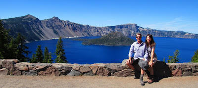
When we arrived at the deepest lake in America, we did so without reservations, willing to just wing it, see the beauty and drive on. Thankfully, we were able to spend the night so we got to sleep in the shadows of a sleeping volcano.
For those unfamiliar with this geological wonder, Crater Lake inspires awe. Native Americans witnessed its formation 7,700 years ago, when a violent eruption triggered the collapse of a tall peak. Scientists marvel at its purity: fed by rain and snow, it’s the deepest lake in the USA and one of the most pristine on earth.
Sitting at its rim takes your breath away. That color!
On previous visits, we have only visited the west side of the 33-mile historic Rim Drive, a scenic route which circumnavigates the lake. Along the drive are 30 overlooks that were designed between 1931 and 1938. Each overlook highlights a specific view of the lake, a significant geologic formation in the caldera, or an environmental feature such as a subalpine meadow. Some of these stops have exhibits with information about the view. Other viewpoints leave room for visitor curiosity and discovery. We chose a route new to us and headed east.
Our first stop was at Vidae Falls, a beautiful 115 ft. waterfall located right on the road.
Our last stop for the night was at The Pinnacles. These towering needle-like formations of rock, called fossil fumaroles, projecting from the Sand Creek Canyon floor, were formed under sheets of volcanic pumice that preceded Mt. Mazama's collapse.
As the surface of the hot pumice cooled over the years, steam and gases were released by the hot rocks underneath through vents and tubes that were welded into cement hardness by their passage. These ancient vents now stand alone due to the erosion of the surrounding softer materials.
After oohing and aahing at nature's awesomeness, we strolled the .5 mile trail and discovered what remains of this very cool historic entrance sign on the eastern border of the Park. The stone boundary marker was constructed by the CCC in 1937. On one side, the sign readed "Department of Agriculture - Forest Service - Entering Winema National Forest" (now the Fremont-Winema National Forest); on the east side, the sign read "National Park Service - Crater Lake National Park - East Entrance - U.S. Department of the Interior." Sometime between 2015 (borrowed photo below) and today, the sign has sadly disappeared.
The east route into Crater Lake National Park was originally constructed by the Army Corps of Engineers in 1913. The Bureau of Public Roads oversaw a substantial upgrading of the road between 1929 and 1935. The entrance was closed in 1956 because of a decline in visitors entering the park from this direction. It was reopened from 1971 - 1973 but was again closed, this time permanently, because only a tiny percentage of park visitors came in this way. Interesting right. Yes, history is everywhere. We can't wait to discover more tomorrow.
“Remember that there is no lake its equal in depth;
no other lake of such size occupying the crater of an extinct volcano;
no other lake surrounded by such artistically colored, rugged mountain walls;
and no other body of water of such a wonderful, indescribable blue.
This coloring, varying from a faint turquoise to the deepest indigo blue,
makes Crater Lake one of the most beautiful spots in America."
-Zane Grey


0 comments:
Post a Comment